Skip to the main content.

Respond to catastrophic weather events with speed and accuracy using 

CAT Response System

Get ahead of catastrophic (CAT) events. Analyze rapidly available post-event imagery with computer vision detections, predict the impact of events to prioritize resources, identify damaged properties, and validate damages for a faster claims process.

Insurance claims teams need a catastrophe response system that enables remote assessment of property-specific impact in near-real-time, to proactively, rapidly, and accurately respond to CAT events. 

Allocate your CAT resources more effectively

Strategically stage your claims response teams such as loss adjusters in areas with a high number of predicted-damage properties, before damage happens. Then after the damages, triage the impacted policies and prioritize resources for properties with great damage or complex claims, for faster claims response. 

CAT-RS Triage sample

Red pins indicate predicted damage properties; Green pins indicate undamaged properties; Blue pins indicate properties with unknown damages.

CAT Response System_customer satisfaction_sample_blur

Side-by-side imagery of damaged property in the Kansas Tornado, April 2022. Our computer vision automatically detects damaged properties, both residential and commercial. This analysis is ready within minutes after the post-event imagery is available. Users can also verify the analysis by looking at the individual side-by-side imagery.

Keep good communication and help customers recover from tragedy faster and easier 

With post-event imagery available within 24-48 hours from the most reputable and comprehensive aerial imagery providers in the world and our proprietary computer vision, you can proactively reach out to customers and jump-start the claims process even before the first notice of loss (FNOL), without needing costly boots-on-the-ground. You can help your customers return to their normal lives faster and easier.

More accurately predict claims losses in near-real-time and cut loss-adjustment expenses (LAE)

Automatic damage detections of individual properties in your portfolio allow for a more accurate and immediate understanding of real damages and losses, for instant financial planning. No more waiting for damage assessment, and no more guessing. A more accurate budget and reserve enable faster claims payments and settlements, which leads to lowered LAE.

CAT Response Wildfire Colorado

CAT Response System empowers speed & accuracy so that you can be ready when your customers need you the most

CAT-RS properties in CAT zones

Identify Risk

We pull near real-time data from trusted geospatial data providers for the latest projection of CAT events. Our system identifies at-risk properties in your portfolio that are within the event area.

CAT-RS Predict Losses

Predict Impact

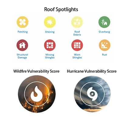
We predict the potential losses with computer vision and our peril vulnerability scores, before the damages even occur. You will be notified of the number of potentially impacted properties and the predicted losses on a portfolio level.

CAT Response System_post-event imagery_blur_no date

Validate Damages

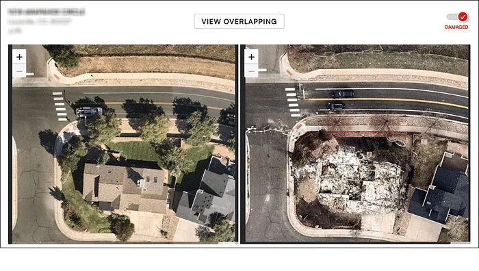
If you subscribe to post-event (grey sky) imagery from providers like Nearmap, high-resolution imagery would be available within 24-48 hours. Our computer vision then automatically detects damaged properties to provide an estimate of the real losses, at both property and portfolio-level. You can also view side-by-side imagery to verify damages. This allows for immediate claims actions and documentation purposes to mitigate fraudulent claims.

CAT Event begins

Near real-time data from trusted public and private sources for the latest projection of CAT events.

CAT-RS Projection of CAT Events

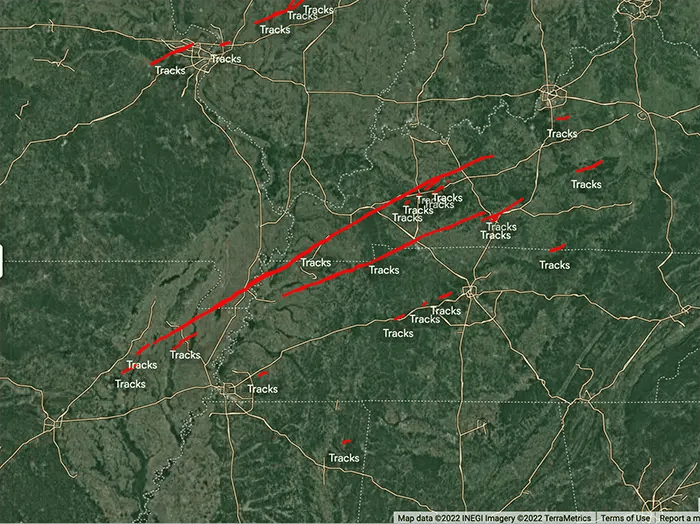
Arkansas & Kentucky Tornado tracks in Dec, 2021

Our system identifies properties in your portfolio that are in the CAT areas and predict the potential damages with computer vision, before the damages even occur. You will get notified of the number of potentially impacted properties and the predicted losses.

CAT-RS properties in CAT zones
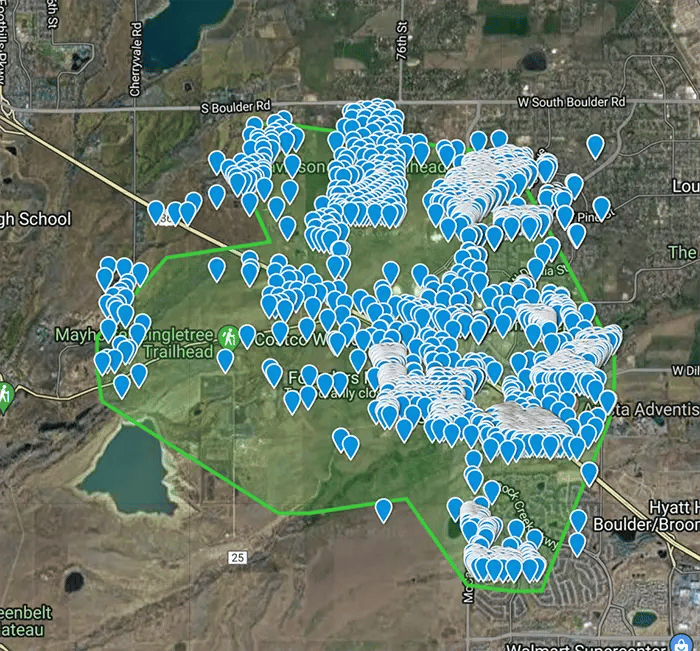
Potentially impacted properties are visualized on a map to show heavily affected areas, before the damages occur.


Our system identifies properties in your portfolio that are in the CAT areas and predict the potential damages with computer vision, before the damages even occur. You will get notified of the number of potentially impacted properties and the predicted losses.

Post-event imagery would be available within 24-48 hours. Our computer vision then automatically detects damaged properties using our proprietary Machine Learning CAT Damage Classifiers to provide an estimate of the real losses, at both property and portfolio-level. You can also view side-by-side imagery to verify damages. This allows for immediate claims actions and documentation purposes to mitigate fraudulent claims.

CAT Response System_post-event imagery_blur_no dateSide-by-side imagery for Boulder, CO wildfire in 2021.

Left: Pre-event imagery ; Right: Post-event imagery

Results

Optimized claims process efficiency

Improved customer satisfaction

Lowered expenses

Hurricane Ian Report Available

Hurricane-Ian-Report-CTA
Click image to download
Betterview Donates CAT Response System to Insurers Affected by Hurricane Ian
  • Over 30 insurers used the system to allocate CAT response resources, proactively alert customers, and understand losses faster and with greater granularity.

  • Identified 663,217 properties in Hurricane Ian's track, and 102,109 in both high wind speed (>90KM/H) and coastal storm surge areas.
  • Pulled in 152,881 post-event imagery and identified 17,226 damaged properties shortly after landfall.
  • The Betterview Hurricane Vulnerability Score was highly predictive of damage - majority of the damaged properties were scored 1 (3.5x more likely to be damaged compared to a score of 5).
  • Helped insurers accelerate claims & recovery.

Download the report today!

Traditional CAT response processes are slow, reactive, and inaccurate. There are lots of waiting and guessing


Regional-level modeling just shows a broad affected area and does not show property-level damage. Insurers are unable to triage policies, have to wait for the First Notice of Loss (FNOL), and have to guess where to put resources. 


Have to wait until the First Notice of Loss (FNOL) to act, then have to wait for boots-on-the-ground, leading to a slow claims cycle and poor customer satisfaction.


Have to wait for damage assessment and loss exposure, thus can only guess the financial impact of the CAT event. Slow and inaccurate loss estimates make it difficult to accurately reserve for anticipated losses